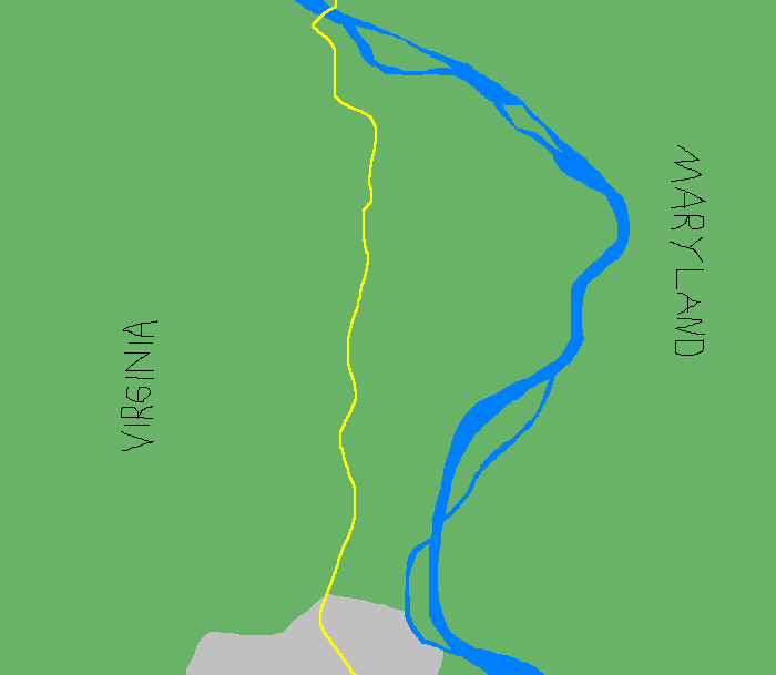
I would like to discuss with you a stretch of road. It's a two-lane road that runs north and south. It has narrow shoulders and no traffic lights, and on both sides of the road can be found fields and woods. To the east of this road is a river, running also in a very general north-south orientation. To the north the river bends to the west and intersects with the road, and there is a bridge. Everything north of the bridge and east of the river is Maryland; everything south of the bridge and west of the river is Virginia. At the southern end of this stretch of road there is a town, Leesburg. It is not a big town, but it is the only real town in that part of Virginia. It is the hub. The road is Route 15.
Strictly speaking, Route 15 is an interstate highway. But the thing you are picturing in your mind when you visualize an interstate highway almost certainly is totally wrong. There are no guardrails on Route 15, no exits, no rest stops; children wait for the school bus to pick them up where their driveways intersect with this road. You are much more likely to encounter a tractor on this stretch of Route 15 than you are a traffic cop. Between the bridge (at Point of Rocks, MD) and Leesburg there are four open-air produce stands and four antique shops, but there are no auto-service stations or fast-food restaurants or pharmacies. There are three gas stations that also sell milk and cigarettes and lottery tickets; otherwise there are horse barns and family farms and stands of trees and patches of disused crop field. Route 15, north of Leesburg, is a country road, one that happens to go from one state into another. Here is a drawing of this stretch of road:
Nevertheless, this stretch of Route 15 is used each morning and each afternoon by many, many commuters. A relatively small number of these commuters live in the relatively few homes between the bridge and the town. A substantially larger portion of the commuters live in and around a somewhat larger town, Frederick, north of the bridge, and commute into the northern part of Virginia for jobs in the region's tech and consulting industries. Many of these people probably had those jobs in northern Virginia before they had their homes in western Maryland, and moved out there because housing is unbelievably expensive in the part of northern Virginia where all the tech businesses are located. Notably, none of these commuters work in, say, a mine or factory; most or all of them could do most or all of their jobs from the comfort of a home desk, but have been ordered back to offices for reasons passing understanding. It's hard to be very mad at these workers for their choice to live in one state and commute long-distance each day for a job in another. Surely they would choose a different, better arrangement if they felt they had the option.
The stretch of Route 15 that these commuters use to get to work each day is not built to accommodate this volume of traffic. For example: When a car accident of any degree of seriousness happens up there between the bridge and Leesburg, on either side of the road, traffic is stopped completely in both directions until the accident scene can be cleared away. Because there are no shoulders, emergency vehicles and wreckers cannot zip quickly to the scene of the accident, and so clearing an accident of any size can take hours, and will completely barricade people who live between the bridge and Leesburg from getting into town for, say, groceries, or doctor's appointments, or to pick their children up from school. This tendency of traffic to become stuck is also a problem when commuters suffer tire or mechanical failures, or when deer bound into the road and get creamed, or when the local letter-carriers have to stop every 200 yards to deliver mail to mailboxes posted directly along the road.
The traffic situation has gotten worse over time. Some part of this has to do with landowners subdividing their properties, or farmers selling off to developers, both along the stretch of Route 15 south of the bridge and also north of the bridge, along the rural stretch headed toward Frederick. The number of homes in neighborhoods directly along this stretch of Route 15 has climbed; because these newer housing developments invariably fall into the hideous McMansion-esque Executive Homes variety, they tend to attract purchasers who have jobs that require that they commute south and east, back to that same tech corridor.
But the increase in population is not the sole cause of the increase in traffic. For a very long time there was a privately owned and operated daily ferry service that crossed the river well south of the bridge. Commuters from east of the river, especially those to the south of the bridge, could pull onto this ferry on the Maryland side, take a pleasant little jaunt across the river, then disembark and cruise up a short paved track through a couple neighborhoods to a stop light, which would allow them to enter onto Route 15 in an orderly fashion, just north of Leesburg. Then, in the evenings, they could dip off of the road at the same intersection, take the ferry in reverse, and zip straight home, cutting 20 miles or more from their daily commute.
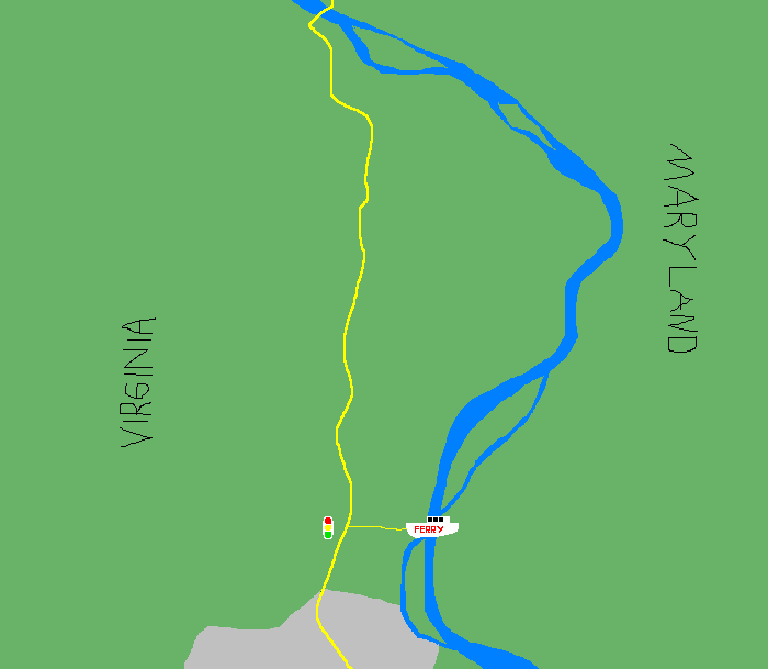
Then, in 2020, a bitter and infuriating dispute between a landowner and the ferry's private operator led to the end of the ferry service. We live in a deranged country where two rich people arguing over proceeds can lead to the indefinite closure of an important commuter route and impose grinding logistical obstacles on an entire region of people. As the next closest river crossing is some 40 miles south by car, everyone who might normally have taken the ferry to enter Virginia each day now must travel north and queue up to cross at the small two-lane bridge at the northern end of this particular stretch of rural Route 15.
This flood of daily commuters down a narrow rural road is a problem. The speed limit on this road is 45 miles per hour, but due to volume the flow of traffic each morning rarely gets above 25 miles per hour, and sometimes it can be stop-and-go, in particular when school buses are out picking up children. At those speeds what ought to be a 12- to 17-minute cruise from the bridge to Leesburg starts to take more like half an hour. There are three spots along this stretch of road where the double yellow line breaks up into short passing zones, and it is not uncommon in the morning to see cars feint out into opposing traffic and then dart back into their spot, or to see a lunatic in a small Honda with a Pennsylvania license plate attempt to drag race a school bus for 40 feet of illicit gain. Local drivers leaving home in the morning sometimes have to wait for 15 minutes or longer just to make the turn off of their road or driveway and onto the only route into town. It's bad for everyone.
Here is where it becomes a nightmare: A large and growing number of workers commuting from Maryland each morning are further disrupting the flow of traffic by availing themselves of a detour that shortens their individual drive time, at the expense of everyone who does not take the detour.
To the west of Route 15 there is a connected set of surface streets, little dipshit country roads that are not meant to handle thru-traffic in any direction. Way up by the river there is an unlined country lane—Route 664—that runs south and connects a series of country homes to the area's only thoroughfare. If you wind along Route 664 and make the correct turn at a T-intersection you eventually wind up on Route 663, an even windier stretch of remote country road. Stick with this and you will come to a four-way stop where Route 663 crosses Route 662. Turn right onto Route 662 and follow it past teeny little country houses and dark stretches of deciduous forest, looking always on your left for the turn onto Route 661. Route 661 goes through an Executive Home subdivision and then finally runs in a straight line back to Route 15. Here is that detour, in pink:
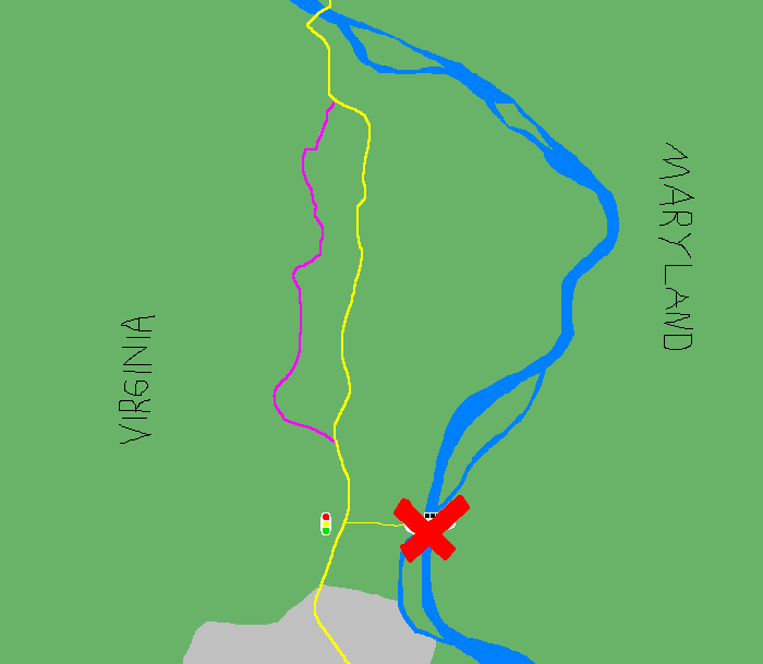
No one would ever prefer to take this squiggly route to work each day, except that commuters are desperate to cut down on their drive time and modern GPS mapping systems are not being programmed to prefer by-God thoroughfares—even wildly inadequate ones—to linked-up neighborhood roads that only incidentally allow thru-traffic*. You take your chances with a route like that: A single fallen tree-limb can render it impassible. But when it's clear and everyone is in the same desperate hurry, you can hustle along at speeds that frankly terrify the families whose driveways connect to these newly misused country lanes. You can cut 20 minutes off your commute if everything goes to plan.
*A quick aside: It used to be that everyone on the Eastern Seaboard who drove south to Myrtle Beach each summer drove on I-95 all the way into South Carolina, and then after driving on I-95 in South Carolina for a while would take the terrible and insanely half-assed state "highway" that leads more or less in a straight line from I-95 to Myrtle Beach. Now no one does that. GPS systems unanimously prefer a North Carolina exit from I-95, followed by a series of increasingly unlikely country lanes meandering south and east. Nowadays you will find yourself in a ridiculous miles-long conga line zig-zagging through sections of remote South Carolina so ill-suited for the occasion that there aren't even lines on the road, with dozens of cars piling up at the only gas station within miles of the route. Ever notice how the obnoxious but ubiquitous billboards for South of the Border have fallen into neglect and disrepair? No one is any longer taking the highway south of the border.
Because traffic is already moving slowly each morning along the stretch of Route 15 where it meets Route 661, drivers headed south tend to slow down or stop to let drivers from Route 661 make the right turn onto the road. But each time a driver on the road stops to let in a car from Route 661, it slows down the traffic behind them a little bit. This has the effect of creating a two-way stop when there is in fact not one: Drivers on the Route 661 detour have learned to aggressively nose out into the slowed southbound traffic on Route 15, and drivers on Route 15 have come to accept that they will be letting a commuter in ahead of them at that intersection. Where there is not a physical stop sign, there is a de facto one.
In the meantime, the traffic on Route 15 from where it meets the bottom of that detour all the way up beyond the bridge is slowed to a crawl. It's a vicious cycle: As commuters dive onto the detour in larger numbers and become more brazen about forcing their way back onto Route 15, they create worse and worse traffic, and put more and more pressure on their fellow commuters to dive off of the thoroughfare and take the detour.
The situation is so bad that when I left my house (north of Leesburg) on Wednesday morning to take my child to daycare, my very own phone advised me that the quickest way to get to Leesburg would be to drive north, on Route 15, and then leave Route 15 and make my way west to the detour, and then to squiggle my way south again in the frantic queue of commuters zooming down quiet country lanes. My phone advised me to be a bad person. I declined!
Traffic loosens up on Route 15 immediately after you pass the imaginary stop sign at Route 661. It still does not move at 45 miles per hour, but it does move. Even without anyone leaving the road, even with the stop light at the old ferry track, the traffic fucking moves! Route 15 is not meant to handle all of this commuter action, but it is a straight line and traffic will move along it as long as people are not jumping in line and creating a busy intersection out of a sleepy neighborhood turnoff.
I live along a road off of Route 15, one that cuts east toward the river. The distance from my home to my child's daycare, near the southern end of Leesburg, is 11 miles. With no traffic, moving near the speed limit, the drive can be done in 18 minutes. Our last five morning trips to daycare have taken an average of 40 minutes; our commute Tuesday morning took 49 minutes. A full 34 of those minutes elapsed covering the 3.5 miles from my home to where Route 15 meets Route 661.
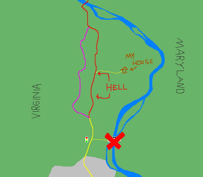
No accidents! No road work! No deer pancakes! No UFOs! No special events of any kind! Just shitty infrastructure, rigged housing conditions, deranged laws, and bad mapping algorithms, working together to gridlock an entire region and send users of a narrow road with too many cars on it into the fires of Hell.
